
Frequently Asked Questions
What is the purpose of this Study?
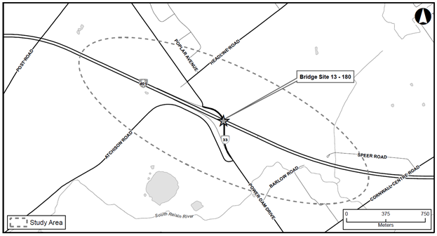
This Preliminary Design and Class Environmental Assessment Study will examine the Highway 401 Power Dam Bridge and Interchange Study. This includes the replacement of Bridge Site 13X-180/BO that carries Power Dam Drive over Highway 401. The Study will also develop the long-term plan for the interchange and establish the footprint for the future widening of Highway 401 to six lanes. The bridge design will consider the future widening of Highway 401, but the EA for the future widening will not be completed as part of this Study.
Highway 401 is a four-lane divided rural freeway at the Power Dam Road interchange. The interchanges current configuration does not allow for all traffic movements on to and off Highway 401. Currently traffic can exit eastbound and enter westbound at this partial interchange. Reasonable alternatives to address the required improvements will be developed and evaluated leading to the selection of the preferred alternative(s) and a Recommended Plan.
The purpose of the Class EA Study is to identify a Recommended Plan for the bridge replacement at Power Dam Drive as part of the Ministry's ongoing review of safety and operational needs for the provincial highway network. This Class EA Study will determine the bridge replacement needs associated with the ultimate six-laning of Highway 401, with consideration for the ultimate interchange configuration. This ultimate, long-term plan for the interchange is to allow the Ministry to update its designation at this site.
The key objectives of the Study are to:
- Develop and evaluate a reasonable number of design alternatives for bridge and operational improvements to select a Technically Preferred Alternative
- Develop a long-range plan for the Highway 401 and Power Dam Drive interchange so that an ultimate interchange design can be established and land protected for future improvements
- Develop a preferred staging and contract sequencing strategy
- Obtain EA approval.
What is the Study Area?
The project is located in the Township of South Stormont, within the United Counties of Stormont, Dundas and Glengarry. Please see key map of the Study Area below.
How does the environmental assessment process work?
This Study will follow the approved planning process for a Group B Project under the MTO Class Environmental Assessment (Class EA) for Provincial Transportation Facilities (2000), an approved process under the Ontario Environmental Assessment Act. During the Study, alternatives will be generated and evaluated based on technical and environmental factors and in consultation with Indigenous Communities, the general public, municipalities and government agencies. Two Public Information Centres (PICs) will be held during this Study to provide interested parties with the opportunity to discuss the Study and provide input to the Project Team. At the end of the Study, a Transportation Environmental Study Report (TESR) will be prepared and made available for a minimum 30-day public and agency comment period.
How will the public be involved during the Study?
To make sure that all interested Indigenous Community members and the general public are contacted, an extensive notification process will include announcements in newspapers and letters to the public, external agencies, local governments, Indigenous Communities, interest groups, local businesses, utility companies and affected property owners. The public will be invited to attend two Public Information Centres (PICs). PIC No. 1 occurred in December 2022 to display and seek input on design alternatives for the Highway 401 bridge replacement at Power Dam Drive. PIC No. 2 will be held in spring 2024 to seek further input on the Recommended Plan.
Invitations to the PIC will be broadly advertised in local newspapers - Cornwall Standard Freeholder (English) and Cornwall Express (French). In addition, this project website has been developed to enable interested Indigenous Community members and the general public to submit their comments via the website. This website will provide general project information, updates and notices of upcoming meetings and milestones and will also host available project documentation (in a PDF format). The Project Mailing List will be updated throughout the Class EA Study.
What is the purpose of the two Public Information Centres?
The purpose of PIC No. 1, which was held in December 2022, provided the community with an opportunity to share information and seek input regarding the project and the alternatives being considered. Online PIC No. 1 introduced the project and the Class EA Study process, provide background information, the problem/opportunity (or need and justification), the existing natural, socio-economic, cultural and technical conditions within the Study Area (including any constraints), Preliminary Design alternatives, the evaluation criteria to be used to assess the alternatives, and the next steps.
The purpose of PIC No. 2, which is planned for May 2024, is to present and receive input on the results of the evaluation/analysis of Preliminary Design alternatives and selection of the Technically Preferred Alternative and the Recommended Plan for the Highway 401 Power Dam Bridge and Interchange Study. A summary of the environmental issues, recommended environmental protection and mitigation measures, and commitments to future works will be presented. Online PIC No. 2 will provide an opportunity for attendees to elaborate on topics discussed in Online PIC No. 1 and will provide another opportunity to discuss issues or concerns directly with members of the Project Team.
Will field investigations be carried out as part of the Study?
Yes, Morrison Hershfield and its sub-consultants will be conducting a series of field investigations within the Study Area. This will include, but are not limited to, geotechnical, natural sciences (fisheries and terrestrial), archaeology, build heritage, and drainage/hydrology investigations, to collect the required background information to describe the existing (baseline) conditions within the Study Area.
Will access to private property be required during the Study?
Yes, Morrison Hershfield and its sub-consultants will require access to some private properties to undertake field investigation work in support of the Study. In these locations, permission to enter will be requested from the property owners. The Ministry's staff, consultant, or sub-consultants will not enter private property without prior consent from the property owner.
Will there be any property impacts?
At this stage of the Study, impacts to properties are not known. Potential impacts to properties will continue to be a significant part of the environmental evaluation process as the Study progresses, leading to the selection of the Technically Preferred Alternative and the Recommended Plan for the Highway 401 bridge replacement at Power Dam Drive. Property impacts will be determined at the completion of the Preliminary Design and Class EA Study and will be presented in the Transportation Environmental Study Report (TESR), which will be released to the public for a minimum 30-day comment period at the conclusion of the Study.
What is the Study timeline?
The Class EA Study is anticipated to be completed in summer 2024. A high-level summary of the planned points of contact are provided below, noting that the dates will be updated / refined as the Study progresses.
- Notice of Study Commencement (January 2022)
- Notice of Online Public Information Centre (PIC) No. 1 (December 2022)
- Notice of Online Public Information Centre (PIC) No. 2 (May 2024) - we are currently here
- Notice of Study Completion / TESR Submission and Public Comment Period (Summer 2024). At this time, the TESR will be released and made available for public / agency comment.
Will external government agencies be contacted during the Study?
Yes, the Project Team has and will continue to contact various external government agencies such as the Ministry of the Environment, Conservation and Parks (MECP), Ministry of Natural Resources and Forestry (MNRF), Ministry of Agriculture, Food and Rural Affairs (OMAFRA), Ministry of Heritage, Sport, Tourism and Culture Industries (MHSTCI), Raisin Region Conservation Authority (RRCA), among others throughout the Study.
How are comments incorporated into the Study?
All comments received during the Study are documented and reviewed for inclusion into the Study, as applicable. Stakeholder input is important to identify issues relevant to community members familiar with the Study Area (e.g., Indigenous Community members, residents, property owners, businesses) and could provide additional insight into the Study. Feedback received enables the Project Team to understand community concerns and/or interests, and to include in the Study, as appropriate.
Information will be collected in accordance with the Freedom of Information and Protection of Privacy Act R.S.O., 1990, c.F.31. With the exception of personal information, all comments will become part of the public record.
How will the recommended improvements tie in with the future Highway 401 widening?
The bridge design will consider the future widening of Highway 401, but the EA for the future widening will not be completed as part of this Study. This Class EA Study will determine the bridge replacement needs associated with the ultimate six-laning of Highway 401, with consideration for the ultimate interchange configuration. The Project Team is aware of adjacent studies along Highway 401 and the MTOs future plans for Highway 401.
When is construction proposed?
Environmental clearance of the Transportation Environmental Study Report (TESR) and completion of the final Preliminary Design Report are anticipated in summer 2024. The project can proceed to construction upon the completion of Detail Design, obtaining funding, obtaining environmental approvals, acquiring property and moving utilities